Location: Lake Chivero, near Harare
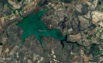
Photo: Google Earth
Map Lake Chivero
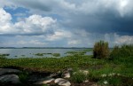
Photo: Petra Ballings
Lake Chivero from Marydale Point.
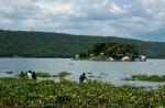
Photo: Petra Ballings
Marydale Point, Lake Chivero
General Information
Quarter degree square: 1730D4 Country: Zimbabwe Habitat: Aquatic, lake shore, mixed deciduous woodland, miombo woodland, wooded grassland, rocky areas and disturbed ground. Altitude range: 1370 - 1400 m Annual rainfall: Location (short): A lake area with recreational and protected wildlife areas created by a dam, c. 35 km Southwest of Harare. Location (detailed): Lake Chivero, formerly called Lake McIlwaine, lies about 35 km Southwest of Harare along the main road to Bulawayo. The lake was created by a dam in the Manyame River and serves as one of the main sources of water for the capital Harare. Areas on the southern shores were proclaimed a National Park in 1952 and are since 1975 known as a Recreational Park. It contains a fenced-in protected wildlife area of c. 6100 ha. The northern shores are set aside for recreation and sport fishing with a Yacht Club, camping ground and Lodge accommodation.
|
Description
Useful links
View a list of records for Lake Chivero, near Harare
View a list of unique taxa (excluding cultivated plants) for Lake Chivero, near Harare
View a list of unique taxa (all taxa whether cultivated or not) for Lake Chivero, near Harare